Over the past three months South Korea has experienced one of its most unusual East Asian summer monsoon (Changma) seasons since 1973. Torrential rains wreaked havoc across the country, causing landslides, flooding and taking lives. Citizens want to know: was the abnormal rainfall in Korea linked to global warming?
The short answer is “no”.
Temperatures on our planet have increased over the past 100 years by about 1oC, global sea level has risen by 20cm, and summer heat waves have become more common in many regions. Human activities, in particular fossil fuel burning, are largely to blame for these changes. However, the fact that our planet is warming on average does not necessarily imply that all regional extreme rainfall events are caused by global warming. There are three main factors that contribute to long-term rainfall changes over Korea: 1) naturally occurring rainfall fluctuations that are unrelated to human activities, 2) global warming, with the tendency to increase Changma by about 2–4% per degree Celsius in global mean temperature rise and 3) anthropogenic aerosol emissions, which tend to reduce summer rain. Climate model simulations clearly show that over the past century, the two anthropogenic factors (greenhouse gases and aerosols) were only minor contributors to the observed variations in rainfall over the Korean Peninsula.
What is Changma?
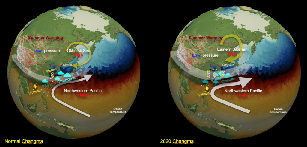
Changma represents the seasonal return of an extended band of tropical moisture and rainfall in summertime. Seasonal warming over continental Asia in June causes air to rise, which creates lower pressure at the surface. More humid air from the ocean is then sucked towards this low pressure. However, instead of moving in a straight line, the air takes a D-tour and flows towards the right of the main pressure force. This effect is due to the Coriolis force (an inertial force, which occurs on rotating objects). Along the twisted clockwise flow, which becomes part of the western Pacificsubtropical high, humid tropical air flows towards the Korean Peninsula. There it encounters drier conditions to the north which can act as an “invisible wall” along which the tropical moisture begins to rain out. This process forms the normal Changma rainband (Fig. 1). As increasing solar radiation warms the continent from June to August, the rainband gradually moves northwards, causing massive downpours first in Eastern China and Japan and later in South and North Korea. However, if we look at daily satellite images, the process becomes more complicated: periods of gradual northward rainband movement are interrupted by short periods of more chaotic flow: associated with the upper atmospheric Jetstream, small low-pressure systems (storms) can form over China and intensify over the West Sea. These relatively short-lived systems (~5-7 days) can suck moisture from lower latitudes towards the Korean Peninsula (Fig. 1). These low- pressure cells typically move eastward following the overall flow of the Jetstream. This process can cause alternating episodes of extreme rainfall and nice weather over the Korean Peninsula. In fact, many of the severe rains over the past two months were associated with such small-scale atmospheric weather disturbances, which interacted with the main large-scale moisture front.
What causes year-to-year changes in Changma?
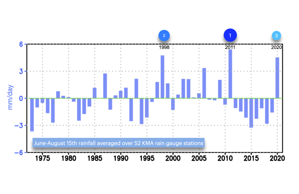
Going back through atmospheric data of the past years, we find that the position of the main rainband and the intensity as well as the frequency of the small-scale weather systems, which are partly responsible for extreme downpours, changes considerably from year to year (Fig. 2). Not every year is the same; some are drier over Korea (e.g. 1992, 1994, 2014–2019), some are wetter, such as 1998, 2006, 2011, and 2020. Why is this? We need to acknowledge first, that the atmosphere can generate such year-to-year changes just through its internal chaotic motion. External drivers such as global warming or differences in oceanic temperature conditions are not required to generate an extreme Changma season.
In addition to the capricious and nearly unpredictable behavior of the atmosphere, external factors can also influence the frequency of occurrence and persistence of rain events. For instance, unusual ocean temperature conditions or snow cover over the Tibetan Plateau can create stationary atmospheric waves(similar to the ripples that form when a stone is thrown into a pond). These large-scale structures of alternating high and low-pressure cells can interact with the local monsoon systems, by bending the wind directions and shifting the path and intensity of small weather disturbances. These processes can alter the transport of moisture towards South Korea and the associated rainfall. Last, but not least, global warming can influence monsoon characteristics in two ways: 1) a warmer atmosphere can hold more moisture; when it rains, there is more moisture available that can rain out, 2) human-induced temperature changes can also trigger stationary atmospheric waves, which could impact the summer atmospheric circulation over South Korea. Which is of these mechanisms acts as the main culprit for the extraordinary Changma condition in 2020 will be discussed below.
Summary answer: Internal atmospheric fluctuations play a crucial role in generating year-to-year changes in Changma.
How unusual was this Changma season?
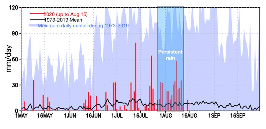
According to a network of rain gauge observations across South Korea covering the last 48 years, the 2020 Changma season (extending from June to August 15th) has been highly unusual, both in terms of total rainfall amount and rain event duration. It ranks third, following 2011 (1st) and 1998 (2nd) (Fig. 2). In the last weeks, more than twice the normal Changma rain fell over South Korea. However, the area-averaged daily rainfall maxima were not unprecedented in 2020 (Fig. 3), which further emphasizes the importance of the rainfall event duration and persistence in explaining the uniqueness of this season, in particular from late July to mid of August.
Summary answer: The 2020 Changma season over South Korea has been abnormally strong, but it ranks only 3rdin terms of June–August 15thaveraged rainfall. A particularly long-lasting rainfall episode from late July to mid of August contributed strongly to the overall season average.
Are there any observed long-term trends of rainfall over South Korea?
Rainfall data for South Korea show no apparent (statistically significant) linear trend over the period from 1973–2020, neither in the June–August 15thaverage rainfall (Fig. 2), nor in the magnitude of extreme rainfall events. Scientists have long known, that, unlike for surface temperatures, it is very difficult to detect the global warming effect in regional rainfall records across the world. This can be explained by the fact that the atmosphere itself is capable of generating a high level of naturally occurring fluctuations in winds and rainfall.
Summary answer: Considering the period from 1973–2020 there are no clear long-term trends in average and extreme rainfall over Korea.
What factors influenced the 2020 rainy season?
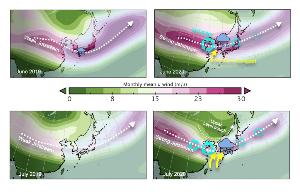
Atmospheric data show that the Korean Peninsula was wedged between very persistent high-pressure systems, one located south of Japan and a smaller and weaker one over eastern Siberia (Fig. 1). Whereas the southern system (related to the Northwestern Pacific subtropical High) provided the moisture for Korean Changma, the northern one created northerly (southward) winds which held the moisture in place over the Korean Peninsula, creating more persistent rain. Furthermore, atmospheric data for June to August show a pronounced strengthening of the jet stream (upper atmosphere westerly winds) over Korea (Fig. 4) and the development of an upper-level trough in July. These unusual conditions doubled the atmospheric potential to generate small-scale low-pressure systems. Such events were observed in particular in late June and early July, drenching Korea in heavy rain. This Changma season is highly dynamic with elongated rainbands, fast-moving low-pressure systems and even typhoons contributing to the mix of unusual weather conditions.
Broadening our view to the entire Northern Hemisphere, a characteristic atmospheric wave pattern, with five alternating low and high-pressure systems spanned the extratropical atmosphere in June–July. The anomalous pressure patterns over Korea in June and July were part of this larger hemispheric wave train, which bears some resemblance to the so-called circumglobal teleconnection pattern. This is an atmospheric flow state, which can emerge simply by internal climatic processes, in particular the interaction between atmospheric waves and mean flow circulation and ocean temperatures.
Summary answer: A strengthening of the atmospheric jet stream triggered small-scale low-pressure cells which in turn enhanced the transport of moisture towards the Korean Peninsula, leading to unprecedented rains. The large-scale hemispheric flow was an important contributor to the persistence of the rainy conditions in Korea.
Did Arctic warming contribute to the 2020 Changma season?
Over the past weeks, some media outlets reported that the recent Arctic warmingmay have played an important role in establishing anomalous atmospheric conditions which in turn contributed or caused the extreme 2020 Changma rain. If correct, this would suggest a linkage between global warming and the unusual conditions over Korea in 2020. However, the statistical and physical evidence for this linkage is weak. Many years of strong Arctic warming in the past, such as e.g. 2012, 2015, 2019, were not accompanied by increased Changma rains, but drier conditions (Fig. 2). Moreover, long-term observations of Arctic temperatures show a clear summer warming trend of about 2oC since the 1980s, whereas such a trend is absent in the observed Korean rainfall data (Fig. 2). The low statistical correlation between these two observations (~0.1) clearly illustrates that averaged summer Arctic temperatures are not a major driver for Korean rainfall variations and only explain a few percent of its year-to-year changes. We also need to emphasize here that it is very difficult to unequivocally link the occurrence of a single regional extreme event (2020 Changma) lasting for only two to three months to a trend which lasted for at least four decades (Arctic warming and sea-ice decline).
Summary answer: The effect of Arctic warming on South Korean rainfall is considerably weaker than other processes such as internal atmospheric instabilities.
How will global warming affect future Korean rainfall?
Global warming is real. Human activities have been the major cause for the observed planetary ~1oC warming since the mid-20thcentury. A warmer atmosphere can hold more moisture due to the thermodynamical Clausius-Clapeyron relationship. If the atmospheric conditions remain unchanged, more moisture leads to more rainfall. However, global warming also influences the large-scale atmospheric circulation. Climate models show that as a result of wind changes, areas that are already quite dry presently (e.g. in the subtropics), are likely to experience on average more severe droughts in future. Scientists refer to this as the expansion of the subtropics. South Korea is located at the northern edge of the subtropics, which means that the effect of future global warming-induced atmospheric circulation changes will also play an important role in generating rainfall trends, in addition to the thermodynamic effect. To determine the impact of global warming on Korean rainfall, scientists at the IBS Center for Climate Physics in Busan use one of Korea’s fastest supercomputers, called Aleph. Running climate models (~1 million lines of computer code, to solve the fundamental physical equations for the atmosphere, ocean, land and radiation), we find that increasing future greenhouse gas emissions over the next decades will lead to an average summer (June to August) rainfall increase over South Korea of about 2–4 % per 1oC global warming. If greenhouse gas concentrations are not reduced substantially, our computer model simulations show that average Korean summer rainfall will increase by about 10–15% over the next 80 years (Fig. 5). However, running these computer models back in time using the observed emissions of greenhouse gases and anthropogenic aerosols, we find a very different result. According to the supercomputer simulations, the combined effect of global warming and atmospheric aerosols caused a slight decrease of summer rainfall over Korea of about -1 to -3% (from 1900 to around 2000). It should, however, be noted that given the large natural year-to-year fluctuations (Fig. 5), the human-induced trend over the past 100 years would essentially remain undetectable in the observed record.
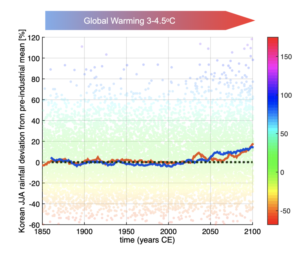
Summary answer: Over the past 100 years, the combined effect of global warming and anthropogenic aerosols, caused a slight reduction in Korean summer rainfall of about -1 to -3%. Over the next 80 years the global warming effect will win over the aerosol effect, leading to a future summer rainfall increase over Korea by about 10-15%, unless drastic action is taken to reduce greenhouse gas emissions.
- Korean article on IBS website: https://www.ibs.re.kr/cop/bbs/BBSMSTR_000000000735/selectBoardArticle.do?nttId=19049
- Reference Video uploaded on ICCP Youtube Channel: https://youtu.be/jUWeE8fBEOs
Authors: Axel Timmermann, June-Yi Lee, Kyung-ja Ha, Junghee Yun, Tamas Bodai, Suyeon Moon, In-Won Kim, Sun-Seon Lee, IBS Center for Climate Physics, Pusan National University, Busan, South Korea.
Media Contact: For further information or to request media assistance, please contact: Kyungmi Park, IBS Center for Climate Physics, Pusan National University (+82-51-510-7715, kyungmi@pusan.ac.kr)
About the Institute for Basic Science (IBS):IBS was founded in 2011 by the government of the Republic of Korea with the sole purpose of promotingthe development of basic science in South Korea.
About ICCP: The IBS Center for Climate Physics (ICCP) seeks to expand the frontiers of earth system science by conducting cutting edge research into climate dynamics and utilizing high-performance computer simulations, with the goal of improving decadal Earth system forecasts and long-term projections.